
Seismic/High Resolution Aeromagnetic data available for UK 33rd round
.jpg "Adrian Heafford")
Seismic/High Resolution Aeromagnetic data available for UK 33rd round
The UK government has released a large amount of acreage with a view to shoring up oil and gas production and providing more security of supply. In addition to regional high resolution aeromagnetic surveys and 27,000 km 2D data, S&P Global own the Ross-Ettrick and Fisher Bank Surveys Figure 1.
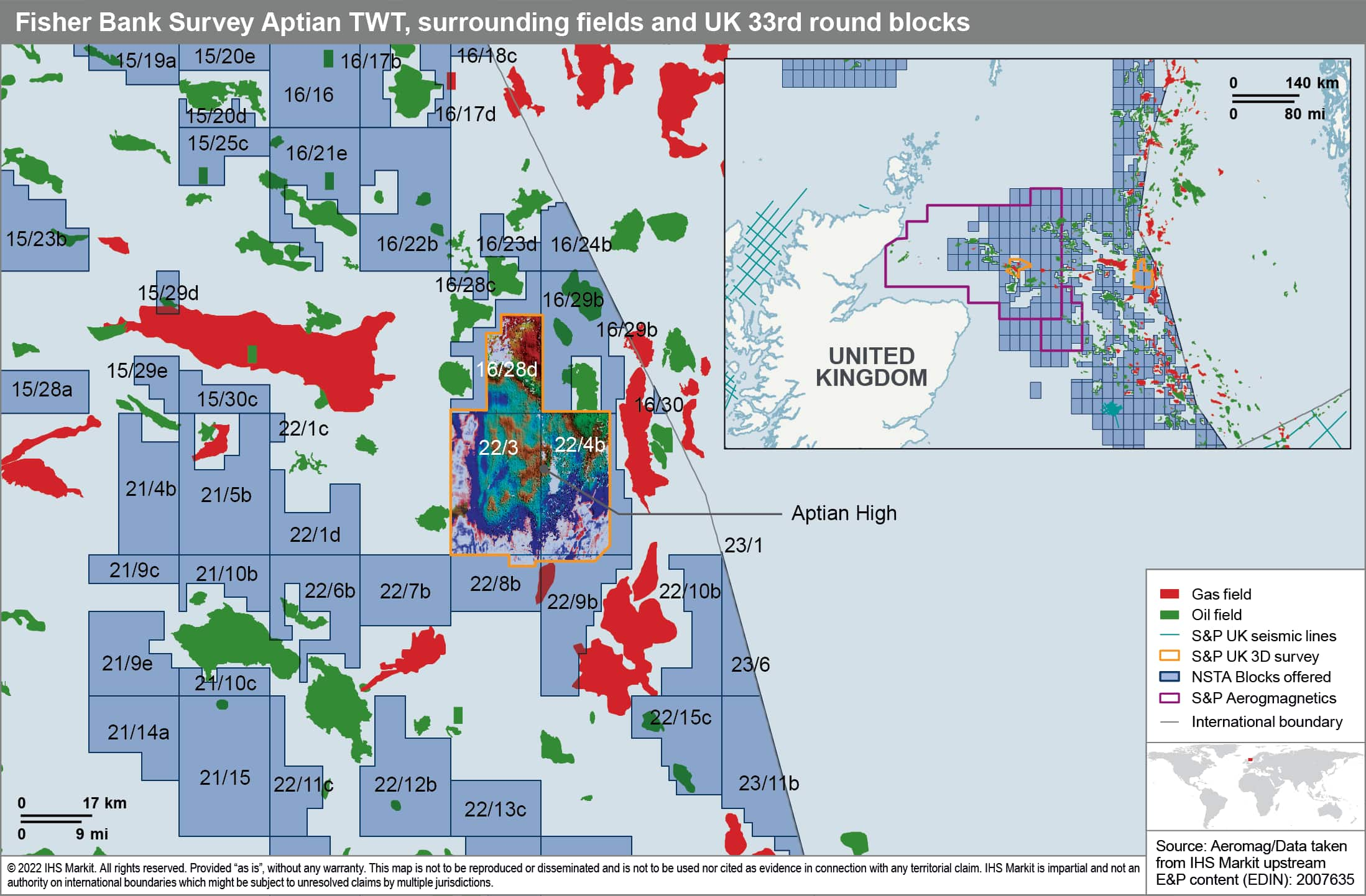 The Fisher Bank survey is of interest
because of its position surrounded by other fields (Shelley and
Maria and the 16/28-12 discovery lie partially within the survey
area) and it is likely a source kitchen area for some of those
surrounding fields. There are reservoir horizons at several
different stratigraphic levels, namely:
The Fisher Bank survey is of interest
because of its position surrounded by other fields (Shelley and
Maria and the 16/28-12 discovery lie partially within the survey
area) and it is likely a source kitchen area for some of those
surrounding fields. There are reservoir horizons at several
different stratigraphic levels, namely:
- Eocene Channels and Lobes
- Palaeocene Mounding
- Chalk high porosity zones
- Aptian Channel and lobes
- Barremian mounding
- Deep Jurassic Structural
The structure varies by stratigraphic level so that at deeper
levels the survey is over a basin but the map above shows that
there are highs within the basin at Aptian level whereas at
Tertiary levels there is a slope from West down to East for example
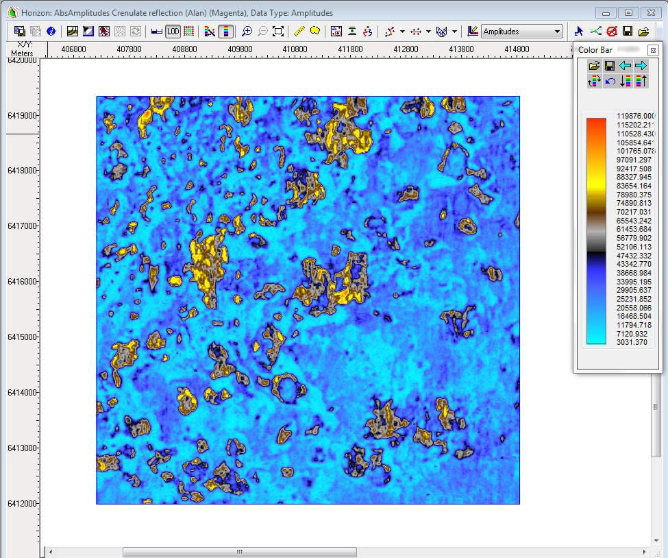
(see figure 2). 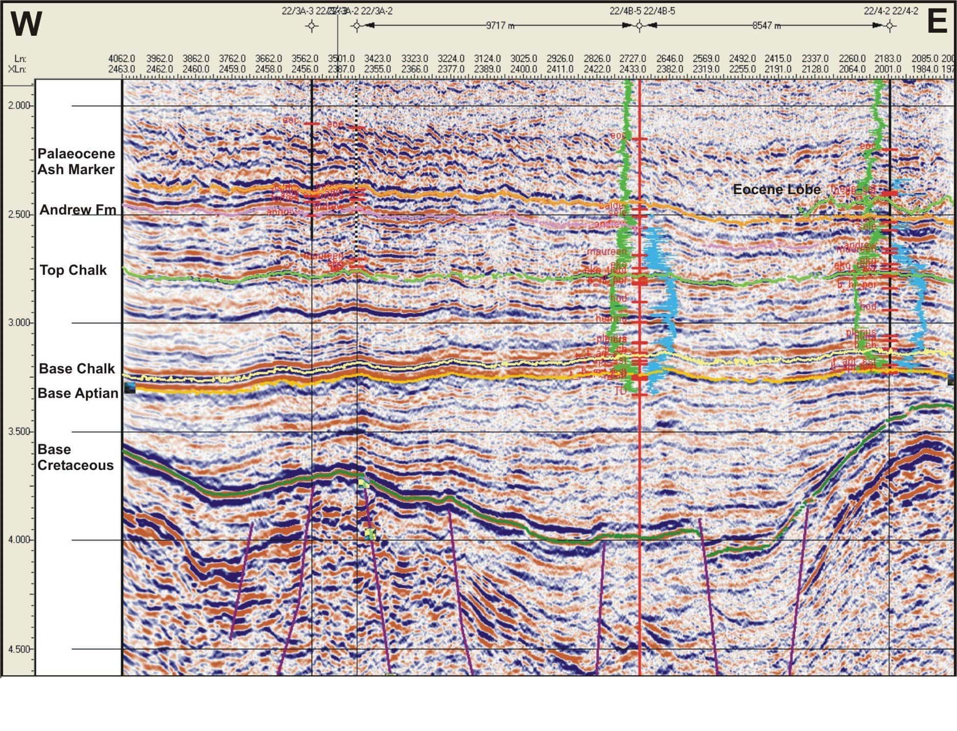 Admiralty charts over the area show a
warning to shipping due to gas seeps. There are many instances of
shallow gas (fig 3) and gas chimneys link the Jurassic and younger
strata.
Admiralty charts over the area show a
warning to shipping due to gas seeps. There are many instances of
shallow gas (fig 3) and gas chimneys link the Jurassic and younger
strata.
There are shows in many of the wells:
- 16/28-8 Eoc and Palc weak gas P 16% K>1000 mD 22/2-10 10' oil & gas shows
- 22/3a-1 Palc oil shows 38ft oil but 61 bbls water on test 20-26% 50-25 mD Aptian oil shows but poor reservoir
- 22/3a-2 "Forties" sand oil shows
- 22/3a-3 "Forties" sand oil shows, porosity 25%, K 35-100mD
- 22/4-1 Eoc weak oil show RFT's not reported. Tor reported porous.
- 22/4-2 Eoc sand but missed main channel, Tor porosity <20% , Aptian gas throughout (no DST's)
- 22/4b-4a Tor 50' thick 30% porosity
- 22/4b-5 Mey dead oil and gas (poss condensate). Tor "Jaeren Chalk fan" Aptian sst < 25' each lots of shows sidewall cores 23-27% and 18-44mD probably dead oil.
The results show that there has certainly been oil and gas
generation and accumulation and there may be prospects elsewhere in
the Aptian or Palaeogene or else in deeper prospects which may be
elucidated with reprocessing. Elsewhere, S&P owned 2D seismic
is available offshore west Wales (though the blocks coincide with
3D surveys from other providers), the east coast of the UK (useful
for the recent Carbon Storage round though there are fields in the
survey area) and in the East Irish Sea. 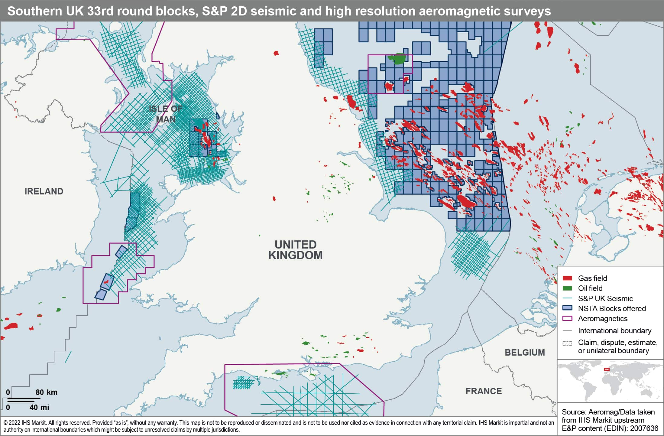 Further interpretation of the Irish
Sea lines can be found in the BGS 21XRM study supported by S&P
and Pharaoh et al., 2019 https://doi.org/10.1144/SP471.7
The fields in the Ormskirk (Sherwood) sandstone are well known but
the study confirmed the Bowland shale source rocks and identified
Variscan inversion structures where the Palaeozoic potential
remains unexplored.
Further interpretation of the Irish
Sea lines can be found in the BGS 21XRM study supported by S&P
and Pharaoh et al., 2019 https://doi.org/10.1144/SP471.7
The fields in the Ormskirk (Sherwood) sandstone are well known but
the study confirmed the Bowland shale source rocks and identified
Variscan inversion structures where the Palaeozoic potential
remains unexplored.
Further information on these surveys is available by contacting: customercare@ihsmarkit.com
This article was published by S&P Global Commodity Insights and not by S&P Global Ratings, which is a separately managed division of S&P Global.