Customer Logins
Obtain the data you need to make the most informed decisions by accessing our extensive portfolio of information, analytics, and expertise. Sign in to the product or service center of your choice.
Customer Logins
BLOG
Jul 04, 2024
Traversing the frontier Langkasuka Basin
Malaysia Petroleum Management (MPM) recently conducted a geological field trip to Perlis and Langkawi to showcase potential for the frontier Langkasuka Basin. Two offshore blocks in this basin, PM-320 and PM-321, are being offered under the Malaysia Bidding Round (MBR) 2024. This unique opportunity allowed us, alongside several international oil companies (IOCs), to gain valuable insight into the onshore analogue and/or extension of the basin's offshore section, situated approximately 200 km west of the Langkawi Island.
The Langkasuka Basin spans from the southwestern region of Thailand to the southern part of the Malay Peninsula coast. It is bordered by the Main Range (locally known as the Banjaran Titiwangsa) to the east, the Mergui Basin to the north, the North Sumatra Basin to the west, and the Central Sumatra Basin to the southwest.
The Langkasuka Basin's long depositional history, under various sedimentological regimes and paleoenvironmental conditions throughout the Paleozoic era, has provided a favorable environment for hydrocarbon generation. Despite its potential, fewer than 10 wells have been drilled in the Straits of Malacca since early 1970s, with most wells located at the edge of Block PM-320, targeting the Tertiary section. Only Singa Besar 1, drilled in 1989, encountered gas in the Paleozoic carbonate. The pre-Tertiary sequence holds immense potential for future exploration.
During the fieldtrip, we were introduced to the potential source rocks such as the Devonian Timah Tasoh Formation of the Setul Group and Carboniferous Telaga Jatoh Formation of the Kubang Pasu Group.These formations were exposed at Guar Jentik Hill C. Total organic carbon (TOC) from both potential source rock intervals ranges between 6% and 14%. One characteristic that distinguishes the Timah Tasoh Formation from the Telaga Jatoh Formation is their fossil content. The Timah Tasoh is rich in fossils, particularly tentaculitids and occasionally trilobites (visible with hand lenses), while the Telaga Jatoh Formation predominantly consists of radiolarian chert. The Kaki Bukit Formation (also known as the Lower Setul Limestone), is a laminated limestone deposit containing stromatolite and microbialite fossils. This formation, which crops out at the Taman Eko-Rimba Bukit Ayer, could also be a potential source rock.
Additionally, promising reservoirs includes the Carboniferous sandstones of the Kubang Pasu/Singa Group, Permian carbonate of the Chuping Formation, and Permian clastics of the Semanggol Formation. The Chepor Member of the Kubang Pasu Group comprises of thick sandstone (up to 60 m thick interbedded with mudstones. This formation can be observed at Bukit Tunjang. The Uppermost Kubang Pasu shares similarities with the Ular Member of the Singa Formation, which is visible at Pulau Ular, Langkawi. Generally, the Kubang Pasu Formation forms north-south trending ridges, while the Chuping Formation forms a series of isolated hills, also trending north-south. Similar repeated structuration forming the fault-bounded gentle roll-over anticline, fault-bound three-way dip closures and tilted fault blocks observed at the outcrops could also extend offshore towards the Langkasuka Basin.
The regionally mappable thick shale sequences in the younger sections of the Kubang Pasu Group are absent in outcrop exposures, mainly due to the intense weathering in the hot tropical climate. Intraformational seals, primarily composed of shale and mudstones, are common characteristic in shallow-water environment seen throughout the Kubang Pasu Group. The thickness of the shale/mudstones, as observed in outcrops, is normally a few meters thick, depending on its deposition locations.
In a strategic move, PETRONAS has partnered with Viridien (formerly known as CGG) in late 2023 to acquire 8,000 km of 2D multi-client seismic survey over the Langkasuka Basin, specifically covering Blocks PM-320 and PM-321. The initiative aims to address the existing seismic data gaps and enhance our understanding of the basin's petroleum system to unlock the untapped potential of the Langkasuka Basin.
Bid submission for PM-320 and PM-321 is open until October 15, 2024. For more information on the bidding round, please contact via email (mbr-query@petronas.com) or visit the MBR2024 website (https://www.petronasmbr.com/). Details on individual block description are also available in GEPS ( Malaysia Bidding Round 2024 - Block Description: PM-320, PM-321 and PM-515).
I would like to again express my sincere gratitude to Malaysia Petroleum Management (MPM) for extending this invitation to this remarkable field trip.
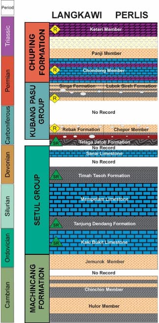
Stratigraphic chart of the Langkasuka Basin (R: Reservoir; SR: Source Rock) (PETRONAS-MPM)
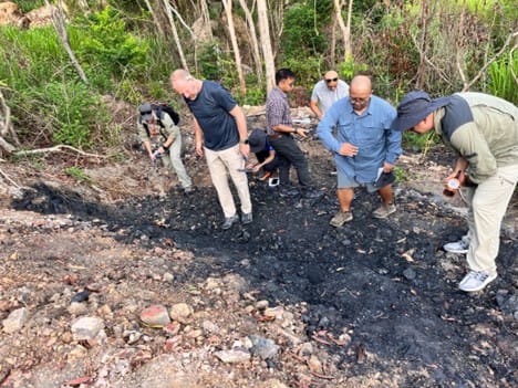
Outcrop exposure of the Devonian Timah Tasoh Formation in Guar Jentik Hill C, the potential source rock of the Langkasuka Basin. (PETRONAS-MPM)
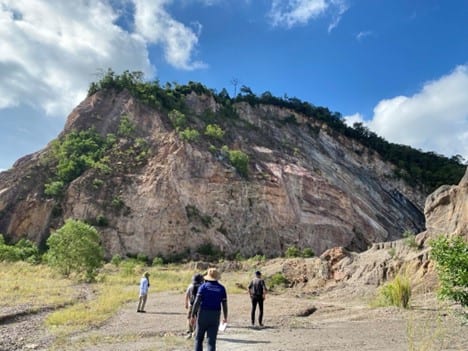
Thick sandstone interbedded with mudstones, the Chepor Member of the Kubang Pasu Group at Bukit Tunjang. Similar structuration is expected to extend offshore towards the Langkasuka Basin. (PETRONAS-MPM)
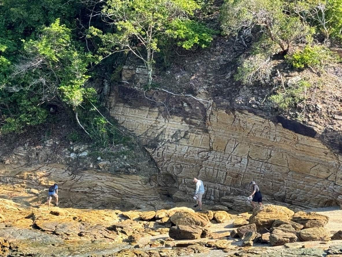
Interbedded sandstone unit with trough cross bedding and shallow-water burrows at Singa Formation (equivalent to the Kubang Pasu Formation). (PETRONAS-MPM)
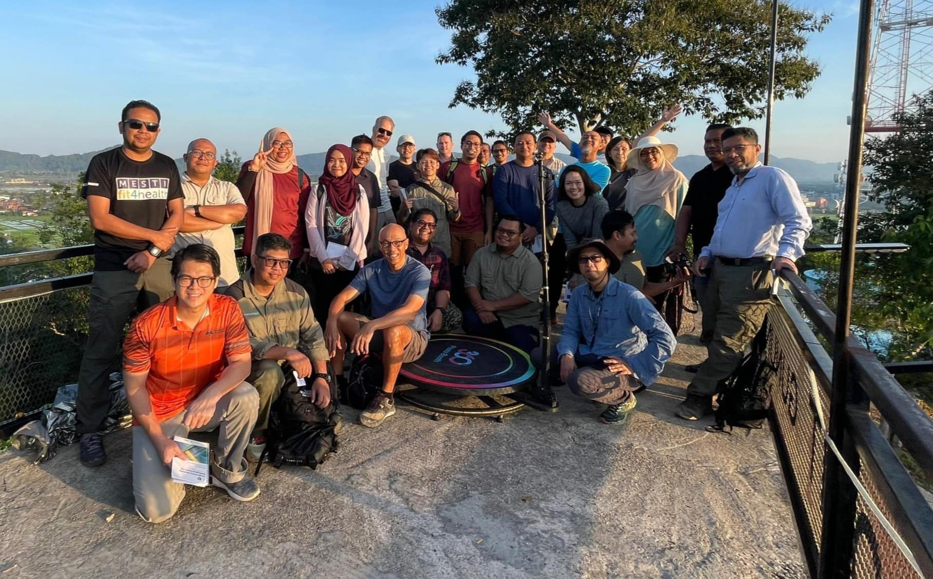
Finally, the participants of the Langkasuka Geological field trip. (PETRONAS-MPM)
This article was published by S&P Global Commodity Insights and not by S&P Global Ratings, which is a separately managed division of S&P Global.
{"items" : [
{"name":"share","enabled":true,"desc":"<strong>Share</strong>","mobdesc":"Share","options":[ {"name":"facebook","url":"https://www.facebook.com/sharer.php?u=http%3a%2f%2fstage.www.spglobal.com%2fcommodityinsights%2fen%2fci%2fresearch-analysis%2ftraversing-the-frontier-langkasuka-basin.html","enabled":true},{"name":"twitter","url":"https://twitter.com/intent/tweet?url=http%3a%2f%2fstage.www.spglobal.com%2fcommodityinsights%2fen%2fci%2fresearch-analysis%2ftraversing-the-frontier-langkasuka-basin.html&text=Traversing+the+frontier+Langkasuka+Basin+%7c+S%26P+Global+","enabled":true},{"name":"linkedin","url":"https://www.linkedin.com/sharing/share-offsite/?url=http%3a%2f%2fstage.www.spglobal.com%2fcommodityinsights%2fen%2fci%2fresearch-analysis%2ftraversing-the-frontier-langkasuka-basin.html","enabled":true},{"name":"email","url":"?subject=Traversing the frontier Langkasuka Basin | S&P Global &body=http%3a%2f%2fstage.www.spglobal.com%2fcommodityinsights%2fen%2fci%2fresearch-analysis%2ftraversing-the-frontier-langkasuka-basin.html","enabled":true},{"name":"whatsapp","url":"https://api.whatsapp.com/send?text=Traversing+the+frontier+Langkasuka+Basin+%7c+S%26P+Global+ http%3a%2f%2fstage.www.spglobal.com%2fcommodityinsights%2fen%2fci%2fresearch-analysis%2ftraversing-the-frontier-langkasuka-basin.html","enabled":true}]}, {"name":"rtt","enabled":true,"mobdesc":"Top"}
]}


